Exploration of Waterfall Way, day two. Another coolish, cloudy 'stralian day today. I did the drive up Waterfall Way this morning. We stopped in Dorrigo at the bakery and Info Centre: the bakery for a treat (Bob had an apple "slice" and I had a cupcake filled with clotted cream and jam), and the Info Centre because Bob wanted to show me a photo of Sherrard Falls covering Waterfall Way (the road) for 100 ft during an extremely rainy, flooding period in 2009. Wow, it's a wonder the road didn't wash out!
I should explain the topography of eastern Australia in New South Wales. We start driving at the coast, go inland through lush, green valleys, then go steeply up the escarpment (cliff) on narrow, winding roads (one lane in each direction...sometimes with semi trucks taking up more than their share of the road) to the plateau.
The plateau has more valleys, high rolling hills, farmland and livestock areas. This is the first waterfall zone with dramatic tall waterfalls spilling over the edge. To us, it is amazing to go up and up through forests and waterfalls only to find more hills and valleys, little villages and cattle country.
From the plateau, we go up again, driving around and through farm country, climb some more mountains and at the top find the tablelands with more farms, cattle and sheep-raising stations (ranches). As we drove higher, the flora changed from rainforest to "dry" rainforest (yes, there is such a thing) and sparser vegetation. Again, amazing waterfalls plunge into rocky gorges, but only if it has been raining or if they are spring fed.
Our waterfall sightseeing today was good, but not all waterfalls had water in them. Oxley Wild Rivers National Park was our first destination to see Wollomombi Gorge. A two-minute walk from the car drew jaw-dropping "oohs" and "ahs" from us. Wollomombi Gorge has not one, but two, dramatic waterfalls fed by two different rivers. You can see change in the vegetation from our rainforest hike yesterday. In this region there is very little vegetation and it is a drier climate.
 |
| Wollomombi Gorge. |
 |
| Wollomombi Falls, 853 ft.--one of Australia's tallest! |
 |
| Chandler Falls |
From Wollomombi Gorge, we continued on Waterfall Way and turned off the highway, drove on an unsealed (gravel road) to see Baker Creek Falls. Right at our turn-off, cattle were ranging across the road and through the eucalypt forest. Standing guard over the herd was this dog.
 |
| On herd guard duty. |
 |
| Metz Gorge--Bakers Creek Falls (dry) |
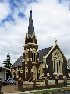
We continued on our way to Armidale, the western terminus of Waterfall way, where we had lunch and walked around downtown and through Central Park. We liked this community.
 |
| Richardson's, 1842 (now houses part of a mall) |
 |
| Dangars Falls, 394 ft. tall--just a trickle. |
Today we learned a little Australian history about bushranger (outlaw) Thunderbolt. We figure he'd be akin to Jesse James or Sundance Kid. He was revered by local country folk for his courage, daring and horsemanship as well as his displays of compassion and humor. He was involved in several shootouts with police, but never killed anyone. He stole only the best horses, many being race horses, to evade capture. Following is a list of crimes said to have been commited by Captain Thunderbolt and his gang:
- One escape from lawful custody
- Numerous firings on police in their line of duty
- Thefts:
~16 robberies of hotels and stores
~16 robberies of gas stations and residences
~6 robberies of hawkers
~Robbery of one tollbar gate
~80 thefts of horses
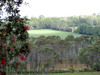
Some scenery from the tablelands:
 |
| View from Dingo Fence Line Rest Area |
Once back in Coffs Harbour, we rested for an hour or so, checked in online, then Bob took me out to dinner for my 60th birthday at Latitude 30 overlooking the Tasman Sea. (I think I forgot to mention: all photos of the ocean taken on this trip so far have been of the Tasman Sea--sounds so exotic, doesn't it?)
 |
| We would have eaten on the deck except for the gale force winds! |
 |
| View from our table overlooking the Tasman Sea. |
Travel Bug out.


