Showing posts with label County Louth. Show all posts

Monday, June 24, 2013

Mellifont Abbey, County Louth

 Mellifont Abbey was the first Cistercian Abbey in Ireland, known to the Cistercians in Ireland as the ‘Mother House’, a base from where the Cistercians expanded, adding more and more institutions (known as ‘daughter houses’) across Ireland. The name Mellifont comes from the Latin, ‘Fons Mellis’ meaning ‘Fount of Honey’.

The Cistercian Order was founded by St. Bernard of Clairvaux in Burgundy, Central France in 1098. St. Bernard believed that the other monastic orders had become dissolute and undisciplined, and he founded the Cistercians as an austere and hard-working order who focused on a life of prayer. St. Malachy of Armagh, the Irish Saint and friend of St. Bernard, founded Mellifont Abbey in 1142 with a group of Irish and French monks.


The Abbey was extremely successful from it’s earliest stages, and it developed rapidly. Monks from Mellifont were dispatched to found ‘daughter houses’ around Ireland, within just five years of the foundation of Mellifont in 1147 a daughter house had already been established at Bective in County Meath and within twenty years the Cistercians had establishments in Connacht, such as that founded at Boyle, County Roscommon in 1161. It is recorded that at least 21 abbeys were founded by monks from Mellifont.
The Cistercian community in Ireland faced a grave crisis following the Norman Invasions of Ireland in the late twelfth century. Irish established Cistercian institutions such as Mellifont became embroiled in a power-struggle with the Cistercian establishments that came from England following the invasion. The outcome of what became known as ‘The Conspiracy of Mellifont’ led to a dramatic reduction in the powers and number of monks allowed to Mellifont. Despite these restrictions, Mellifont remained one of the richest monastic institutions in Ireland due to it’s huge landholdings of the rich agricultural land of Meath and Louth.

It was probably due to this vast ownership of prime land that Mellifont was one of the first of the Irish monastic sites to be Dissolved in 1539 during the Dissolution of the Monasteries. Mellifont became the private fortified home of Sir Edward Moore, and it was here that the famous Treaty of Mellifont was signed in 1603 that ended the bloody Nine Years War. Later Mellifont played host to William of Orange, who established his headquarters at Mellifont during the Battle of the Boyne in 1690.


Of the site itself there isn’t much of the original Abbey left standing today. However excavations have revealed the foundations of many of the buildings, so it is easy to get a good sense of the size and layout of this important Abbey. Mellifont became the standard format for all Cistercian Abbeys in Ireland, and many other monastic orders were influenced by the layout. The cloisters were positioned at the south, and were surrounded by a range of domestic and spiritual buildings, with a cruciform shaped church to the North. The site is certainly worth visiting for its famous Lavabo. This building is in the Romanesque style of architecture, and dates to the early thirteenth century. It is octagonal in shape and served as the ritual washroom, where the monks would wash their hands before entering the refectory for meals. Excavations revealed fragments of lead pipe that brought the water into the central fountain. The interior was decorated with delicate images of plants and birds. A number of fragments of the fine architectural features are on display in the visitor centre.
You’ll find Mellifont about 10km north-west of Drogheda, off the R168 (Drogheda-Collon Road). Guided tours are available from the Office of Public Works from the 30th May to the 28th August. Open daily from 10.00am – 6pm (please note that last entry is at 5pm). Prices are €3 for an adult, €2 for over-60’s, €1 for children/students. For more details please see their website here.

I hope you enjoy this blog, we're trying to cover as many sites as we can across Ireland. If anyone has any suggestions about sites you'd like us to cover please do leave us a comment. If you enjoy information and images of Irish heritage sites then do follow us on Facebook, Twitter and Google+ If you'd like to support us then please consider downloading an audioguide to one of Ireland's wonderful heritage sites. They are packed with original music and sound effects and are a great way of experiencing the story of Ireland. They only cost €1.99 and are fun whether you are at the site, or listening from the comfort of your own home. If you enjoy stories of the turbulent medieval period in Ireland try our guide to Viking and Medieval Dublin, visit us at www.abartaaudioguides.com for free previews and to download your free audioguide to the Rock of Dunamase or the free audioguide to the wonderful heritage town of Kells in County Meath

All photographs © Neil Jackman / abartaaudioguides.com

Friday, May 31, 2013

Carlingford Historic Town, County Louth

Carlingford in County Louth is a beautiful atmospheric town that still retains it's medieval character. Carlingford was founded at the beginning of the thirteenth century by Hugh de Lacy (the younger son of the Hugh de Lacy who constructed Trim Castle). He began by constructing a strong castle on an outcrop of rock that overlooked the Lough, and soon afterwards a settlement began to flourish in the shadow of the fortress. The name Carlingford has a number of possible origins, many of which appear to have a blend of the Gaelic Irish Cairlainn meaning bay of the hag, and the Norse Viking Fjord. Carlingford would have been an ideal location for a Viking Longphort or Overwinter Camp, but no evidence has been discovered so far to conclusively prove a Viking settlement.
The town flourished during the fourteenth, fifteenth and sixteenth centuries, and many of the beautiful buildings listed here date to that period.  The town entered a steep decline however throughout the seventeenth century, a turbulent time in Irish history of war, famine and plague. The town was overshadowed by the near neighbours Dundalk and Newry which quickly developed into bustling urban centres, while Carlingford stagnated. However this decline served to protect the historic structures of Carlingford, as there was little development here in comparison to Dundalk, ensuring that today it is a wonderfully atmospheric place to visit. Here are some of the main features of the town (in no particular order).
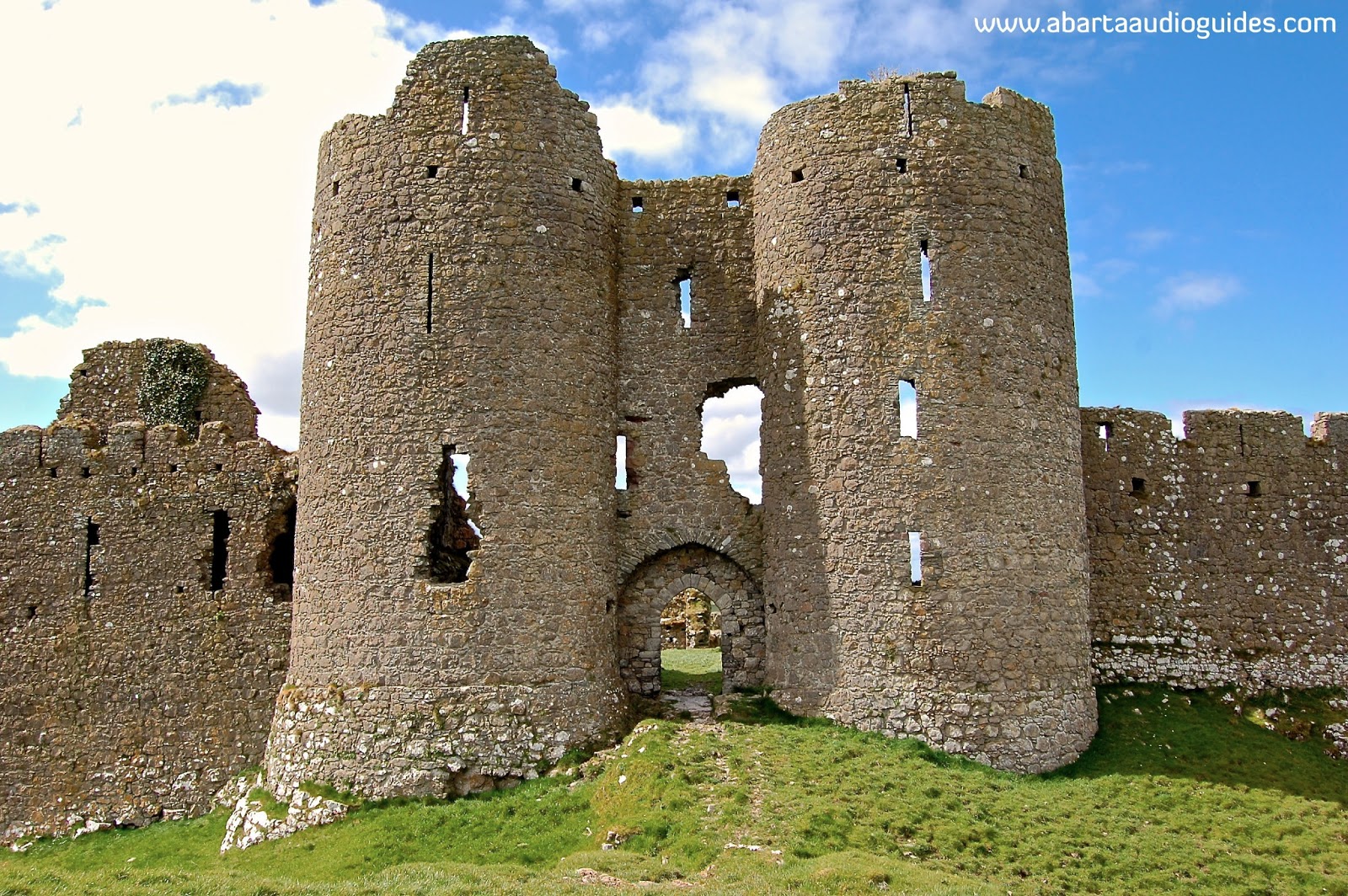
 King John's Castle

The castle at Carlingford was established by De Lacy in around 1200 AD. It was named after King John who took the Castle in 1210. The castle is essentially a D shaped enclosure with a large curtain wall and projecting towers. It appears to have undergone regular alterations throughout the later medieval period, but by the later part of the sixteenth century it appears that the castle had already become derelict as it was described as being 'in a wretched condition'. The Office of Public Works began conservation works on the castle in the 1950's, and it is currently undergoing more conservation works so there is no access to the castle for the moment.

The Tholsel and Town Wall

The 'Tholsel' is the only surviving medieval gateway into Carlingford, and probably dates from the fifteenth century. Originally this would have been a three storey structure, but it has been modified in the nineteenth century and is now two storey with a modern slate roof. This gateway would have given access to the main street at the Eastern end of the town, with a levy being paid at the gateway before any goods could enter the town. There is very little of the medieval town walls left today, you can find a short section just south east of the Tholsel, and the other is at Back Lane at the north-west end of Carlingford.

Holy Trinity Church

The church of the Holy Trinity is an early nineteenth century Church of Ireland place of worship that has many clues of medieval structures that may have originally been on the site. The pointed doorway on the south wall appears to be from the seventeenth century or perhaps slightly earlier, and the church is attached to a tall three storey crenellated tower that may originally date back to the fifteenth or sixteenth century. The eighteenth and nineteenth century renovations makes the origins of this site a little unclear, but it is still well worth dropping in as the Church was leased to the Carlingford Lough Heritage Trust and is now a visitor centre.

Carlingford Priory


The remains of this Dominican Friary date back to the early fourteenth century. The Dominicans were invited to establish a foundation in Carlingford by the powerful Richard de Burgo. The Friary followed the usual convention of a Dominican establishment, with a cloister, a church, dormitories, a refectory and kitchen and a small mill that would have operated on the stream that runs alongside the site. Today you can still see the nave and chancel church with a fine tower.
The Friary reflects the turbulent times during the late fourteenth and early fifteenth century, when raids on such monastic sites were common. The buildings were fortified and battlements were added to make the site more defensive, including a machicolation above the entrance.
The site was dissolved during Henry VIII's reign in 1540, but Dominicans returned to the site in the late seventeenth century.
You can access the interior of the site and explore the nave and chancel church, and the partial remains of the residence block.

The Mint

The Mint is located on the main street a short walk from the Tholsel Gate. It is a fortified townhouse that dates to the fifteenth – sixteenth century.
The name 'The Mint' presumably derives from a 1467 charter that granted Carlingford permission to strike its own coins, however it is more likely that this structure is simply the well built and defended townhouse of one of Carlingford's prosperous merchants during the late fifteenth or early sixteenth century.

One of the great features of this building is the beautfully decorated limestone windows. Each one bears a different design, and perhaps shows a harkening back to pre-Norman Romanesque design that may have been fashionable at this time.

Unfortunately it appears that you cannot access the interior of The Mint.


Taffe's Castle

Taffe's Castle is another good example of a fortified medieval Irish townhouse. As it is positioned close to the harbour front it was probably the home of a wealthy merchant, and is likely to have also served as a well protected warehouse for their goods. The usual layout of a fortified townhouse from this period is to have all the public business conducted on the bottom and lower floors, and the upper floors as the residence. The name is likely to derive from the powerful Taafe Family, who became Earls of Carlingford in the middle of the seventeenth century.

Unfortunately it appears that there is no way to access the interior of Taffe's Castle.
 ________________________________

This is just a very brief overview of a wonderful historic town. Carlingford is certainly worth a trip to enjoy the atmospheric medieval streets and beautiful scenery. Nearby you can visit a number of sensational heritage sites, particularly the fantastic Castleroache.

I hope you enjoy this blog, we're trying to cover as many sites as we can across Ireland. If anyone has any suggestions about sites you'd like us to cover please do leave us a comment. If you enjoy information and images of Irish heritage sites then do follow us on Facebook, Twitter and Google+ If you'd like to support us then please consider downloading an audioguide to one of Ireland's wonderful heritage sites. They are packed with original music and sound effects and are a great way of experiencing the story of Ireland. They only cost €1.99 and are fun whether you are at the site or listening from the comfort of your own home. Our latest guide is to Viking and Medieval Dublin, visit us at www.abartaaudioguides.com for free previews and to download your free audioguide to the Rock of Dunamase

All photographs © Neil Jackman / abartaaudioguides.com 

Sunday, April 21, 2013

Castleroache, County Louth

Like The Rock of Dunamase, Castleroache is positioned high on a rock outcrop that towers over the surrounding landscape. Castleroache is possibly the finest example of Ireland's mid-thirteenth century castles, it is thought to have been constructed by Lady Rohesia de Verdun in 1236 to serve as a bastion of defence for the Anglo-Norman colony in Louth against the Gaelic tribes of Ulster. Lady Rohesia was a formidable woman, and is said to have thrown the castle's architect through one of the tower windows so he could never reveal the castles secrets. 

The castle is nearly triangular in shape with a projecting tower at the north-east angle. It is protected on three sides by the precipitous slope that surrounds it, with the entrance on the eastern side protected by a deep rock-cut ditch. A wooden drawbridge would have led to the interior of the castle through the two massive D-shaped towers. The drawbridge may once have had additional protection from outworks or a barbican gate but no clear above-ground remains of that can be seen today. 

These towers are rounded at the front in the defensive style of the time with a number of arrow loops at varied levels to allow the archers defending the gateway to loose murderous volleys on the attacking enemy. The towers also  have four stories at the rear that would have provided accommodation and living space for the garrison of Castleroache. 

As you can see in the images of the eastern entrance side of the castle, there are a number of rectangular cavities regularly spaced along the wall near the top (the image above gives the best angle to see them). These are 'put-log' holes, and are evidence that once wooden battlements or hoardings, once hung over the side of the castle walls, similar to those that once surrounded the mighty Keep of Trim Castle, in Co. Meath. From these wooden hoardings, defenders would have been able to fire arrows and throw stones down onto anyone attacking the walls, adding to its already formidable defences.
Area of Great Hall
However, like Dublin Castle and Kilkenny Castle, Castleroache seems to have been a keepless castle, so there was no central defensive tower to retreat to had the walls been breached. This appears to have become the defensive fashion of the mid-thirteenth century, and instead of a keep there would have been a large great hall. In the case of Castleroache, the great hall was located on the southern side of the castle (to the left as you enter through the towers).


This castle still strongly exudes a feeling of power and dominance over the landscape today. It has to be one of the most impressive heritage sites I have visited in Ireland, and it is one of those sites that is so massive, so imposing and so breathtaking that pictures cannot do it justice – it is one you must experience for yourself to gain a true impression of its size and grandeur.

To find Castleroache from Dublin, head north on the M1 and exit at Junction 17. Take the first exit off the roundabout following signs for the N53/Castleblaney, continue out on this road until you see a right-hand turn signed for Castleroache and Forkhill, take this turn and follow the road, the site will be on your right hand side up a laneway. Park on road, and please be aware that the site is on farmland, please do not block any gateways and please ensure all gates are closed behind you. Simply walk up the slope through the field to access the castle, there is an interpretation panel on your right hand side when you enter through the gateway.

I hope you enjoy this blog, we're trying to cover as many sites as we can across Ireland. If anyone has any suggestions about sites you'd like us to cover please do leave us a comment. If you enjoy information and images of Irish heritage sites then do follow us on Facebook, Twitter and Google+ If you'd like to support us then please consider downloading an audioguide to one of Ireland's wonderful heritage sites. They are packed with original music and sound effects and are a great way of experiencing the story of Ireland. They only cost €1.99 and are fun whether you are at the site, or listening from the comfort of your own home. If you enjoy stories of the turbulent medieval period in Ireland try our guide to Viking and Medieval Dublin, visit us at www.abartaaudioguides.com for free previews and to download your free audioguide to the Rock of Dunamase  or the free audioguide to the wonderful heritage town of Kells in County Meath
All photographs © Neil Jackman / abartaaudioguides.com